Powys Rivers – Maps
There have been a number of articles in the press recently about the poor quality of the water in our rivers due to intensive farming, and the consequent effect on wildlife. A couple of further links have been included below. A search on the internet will no doubt find you others, and the problems are not just here in the UK.
This one is October 2020 from the Guardian.
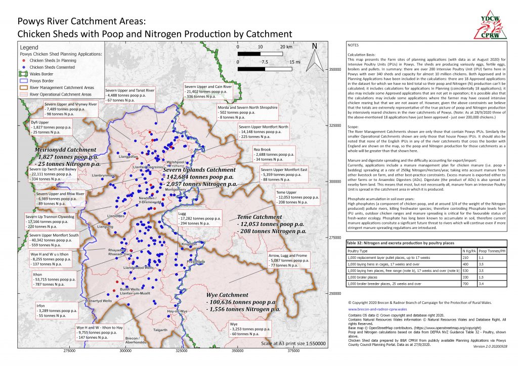
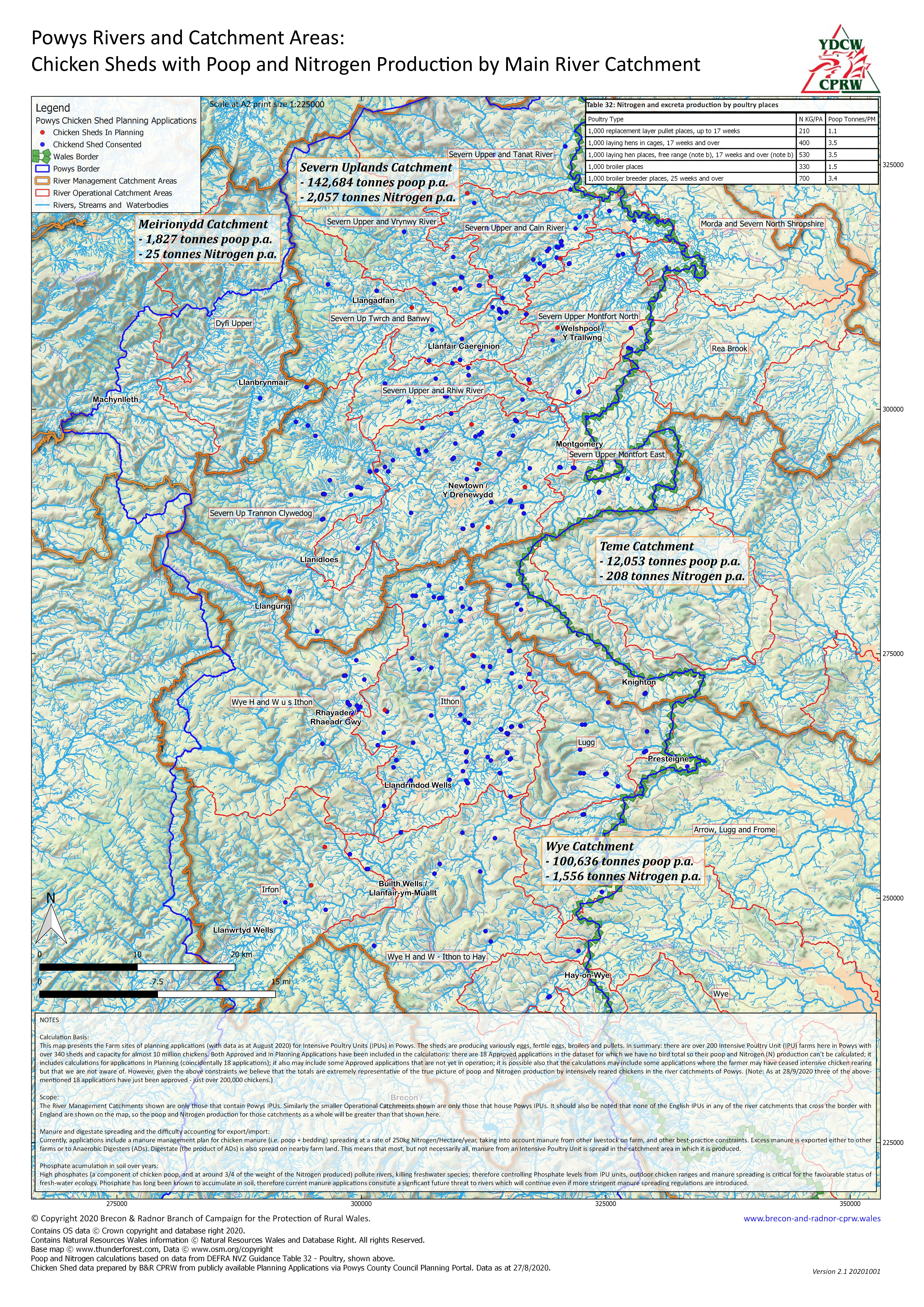
We have recently developed some maps showing the the scale of the Intensive Poultry Units (IPUs) in Wales, specifically intensively-reared chickens in Powys, and the effect on the Wye and Severn river catchment areas.
You may click on the map images above to download high-resolution files (PDFs) of the maps, where you may browse and zoom in detail.
For your convenience here we have extracted the NOTES from the maps and present them below for ease of reading online.
NOTES
Calculation Basis:
This map presents the Farm sites of planning applications (with data as at August 2020) for Intensive Poultry Units (IPUs) in Powys. The sheds are producing variously eggs, fertile eggs, broilers and pullets. In summary: there are over 200 Intensive Poultry Unit (IPU) farms here in Powys with over 340 sheds and capacity for almost 10 million chickens. Both Approved and In Planning Applications have been included in the calculations: there are 18 Approved applications in the dataset for which we have no bird total so their poop and Nitrogen (N) production can’t be calculated; it includes calculations for applications In Planning (coincidentally 18 applications); it also may include some Approved applications that are not yet in operation; it is possible also that the calculations may include some applications where the farmer may have ceased intensive chicken rearing but that we are not aware of. However, given the above constraints we believe that the totals are extremely representative of the true picture of poop and Nitrogen production by intensively reared chickens in the river catchments of Powys. (Note: As at 28/9/2020 three of the above-mentioned 18 applications have just been approved – just over 200,000 chickens.)Scope:
The River Management Catchments shown are only those that contain Powys IPUs. Similarly the smaller Operational Catchments shown are only those that house Powys IPUs. It should also be noted that none of the English IPUs in any of the river catchments that cross the border with England are shown on the map, so the poop and Nitrogen production for those catchments as a whole will be greater than that shown here.Manure and digestate spreading and the difficulty accounting for export/import:
Currently, applications include a manure management plan for chicken manure (i.e. poop + bedding) spreading at a rate of 250kg Nitrogen/Hectare/year, taking into account manure from other livestock on farm, and other best-practice constraints. Excess manure is exported either to other farms or to Anaerobic Digesters (ADs). Digestate (the product of ADs) is also spread on nearby farm land. This means that most, but not necessarily all, manure from an Intensive Poultry Unit is spread in the catchment area in which it is produced.Phosphate accumulation in soil over years:
High phosphates (a component of chicken poop, and at around 3/4 of the weight of the Nitrogen produced) pollute rivers, killing freshwater species; therefore controlling Phosphate levels from IPU units, outdoor chicken ranges and manure spreading is critical for the favourable status of fresh-water ecology. Phosphate has long been known to accumulate in soil, therefore current manure applications consitute a signficant future threat to rivers which will continue even if more stringent manure spreading regulations are introduced.
[Published October 2020]