CALL FOR CITIZEN SCIENTISTS!!
Our rivers are failing.
Befriend your local river and join us to use people-power to understand what is happening and what we can do to save the Lugg and Upper Wye.
Natural Resources Wales (NRW), the Welsh Agency responsible for our natural environment and rivers, reviewed their water monitoring data last year and discovered that over 60% of all the Welsh rivers designated as Special Areas of Conservation (SAC) were failing. This includes the River Wye and its Welsh tributaries. NRW did not include the river Lugg because it is only designated as an SAC downstream in Herefordshire, but we know the welsh Lugg is suffering the same pressures as the rest of the Wye rivers.
Cardiff University is offering support to a CITIZEN SCIENCE project to monitor water quality in the Wye catchment (the area where all watercourses eventually drain into the Wye) over the next year. An experienced and enthusiastic scientific team is acting as an umbrella organisation for local groups to get to know their rivers by organising their own monitoring and sharing the results. Cardiff University will help with training materials and scientific support. This is a golden opportunity to join a collaborative effort to find out what is happening to the whole Wye in both England and Wales.
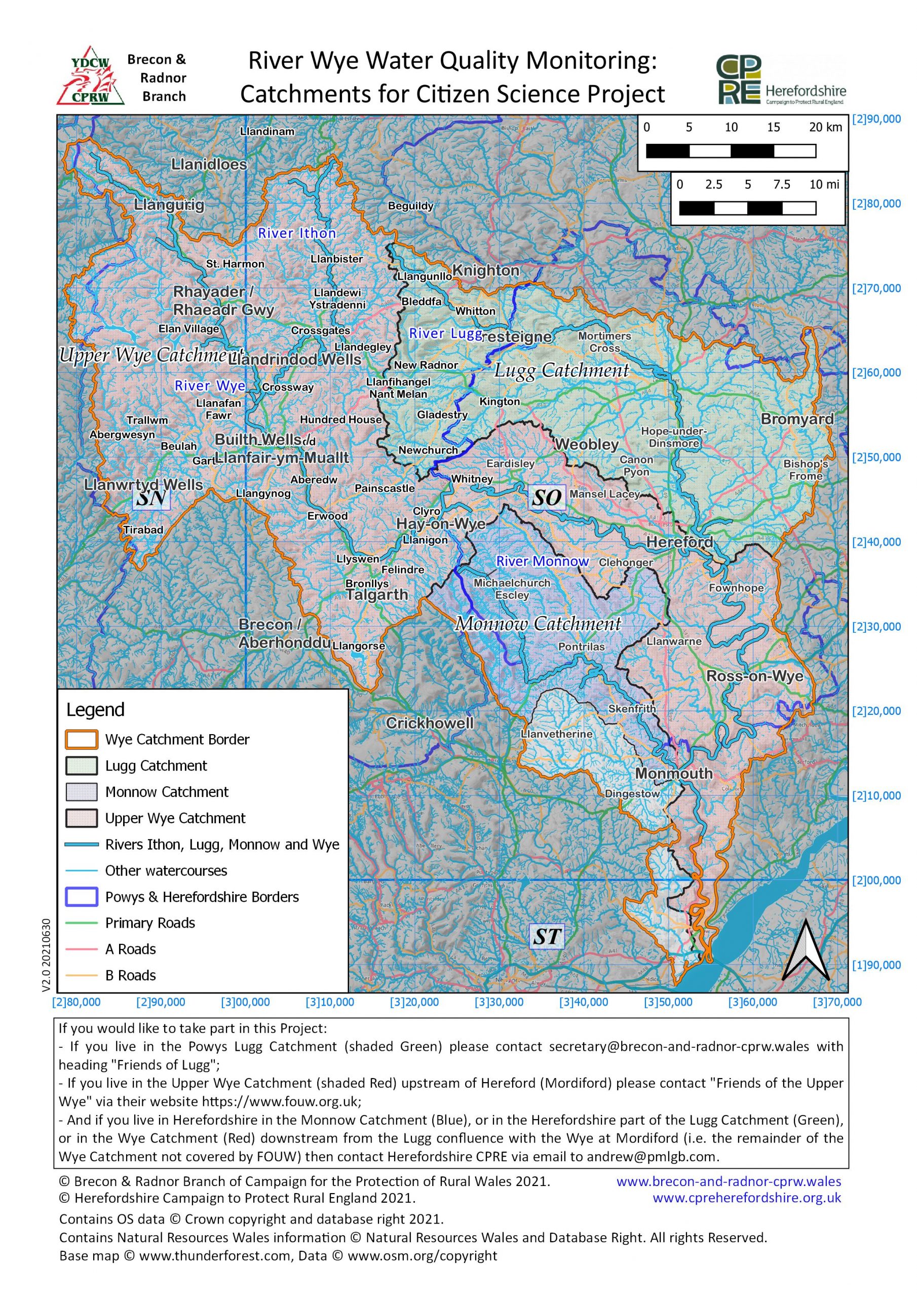
BRECON AND RADNOR CPRW is teaming up with RADNORSHIRE WILDLIFE TRUST to organise monitoring of the Lugg streams and rivers. This work will complement the monitoring already planned by the FRIENDS OF THE UPPER WYE, which will monitor the main Wye and its tributaries. Between us, we will cover the whole Wye catchment in Powys (the area bordered in orange in the map below).
We need people to monitor throughout the welsh Lugg rivers, and also people to help with organisation and to support the citizen scientists with data entry.
If you wish to volunteer as a Citizen Scientist, to help you determine whether you live in the Powys Lugg Catchment, the Herefordshire Lugg Catchment, the Monnow Catchment or in the main Powys Upper Wye Catchment the map below should help you.
If you live in the Powys Lugg Catchment (in green below) and would like to take part in this project, please contact secretary@brecon-and-radnor-cprw.wales with heading “Friends of Lugg”.
If you want to help but live in the Powys Upper Wye Catchment (in red, upstream of Hereford / Mordiford) please contact “Friends of the Upper Wye” (FOUW) via their Website https://www.fouw.org.uk.
And if you live in Herefordshire in i) the Monnow Catchment (blue), or ii) in the Herefordshire part of the Lugg Catchment (green), or iii) in the Wye Catchment downstream from the Lugg confluence with the Wye at Mordiford (in red), i.e. the remainder of the Wye Catchment not covered by FOUW, then contact Herefordshire CPRE via email to andrew@pmlgb.com.
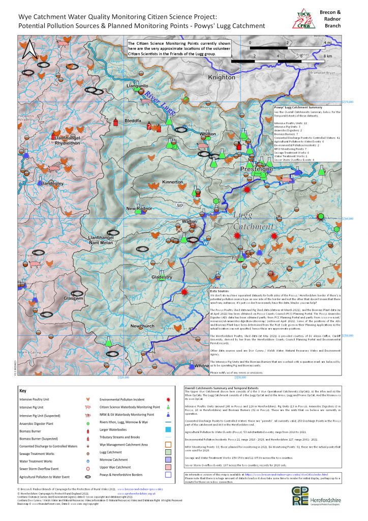
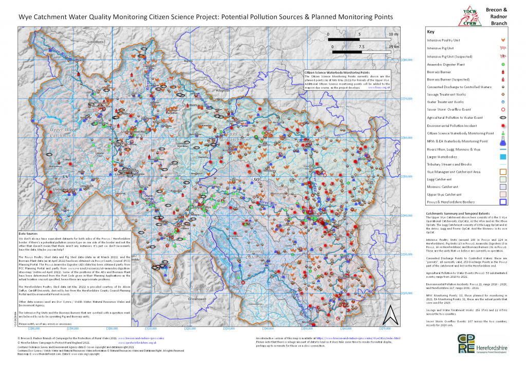
Here is a map of the Powys part of the Lugg Catchment showing the waterbodies and potential pollution sources, together with the approximate sites of our Citizen Science volunteer sampling points – so far. If you click on this link or on the map itself you can download a high resolution PDF version of the map.
We now have an interactive map available that we believe will enable Citizen Science volunteers to identify possible waterbody sampling points in their area. See here, or click on the static image of the interactive map below. We will continue to update it as information becomes available. (There is a lot of data to show on the interactive map so it does take a little time to render completely.)
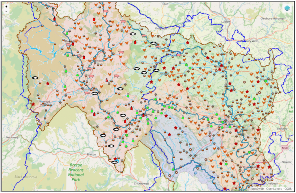
And to download a static PDF map containing all the essential detail, including that part of Herefordshire in the Wye Catchment (part of the larger project), smaller watercourses and supporting notes, click here, or on the snapshot of that map below. The PDF download map is high resolution and designed for printing at A2 so you can zoom in a long way for the topographic detail of interest.
[Updated June 2021]